
Fun geography facts
Scroll a feed of surprising, Wikipedia-grounded geography facts. When something catches your eye, tap the card to flip it and learn what the place actually is.

The name Sudan derives from the Arabic bilād as-sūdān, meaning 'The Land of the Blacks'.
Sudan
Sudan, officially the Republic of the Sudan, is a country in Northeast Africa. It borders the Central African Republic to the southwest, Chad to the west, Libya to the northwest, Egypt to the north, the Red Sea to the east, Eritrea and Ethiopia to the southeast, and South Sudan to the south.
From the “Etymology” section
Text from Wikipedia, CC BY-SA 4.0.
Photo: walter callens · CC BY 2.0

Jönköping became the first city in Sweden to be granted its rights by king Magnus Ladulås on 18 May 1284.
Jonkoping
Sweden
Jönköping is a city in southern Sweden with 112,766 inhabitants (2022). Jönköping is situated on the southern shore of Sweden's second largest lake, Vättern, in the province of Småland.
From the “History” section
Text from Wikipedia, CC BY-SA 4.0.
Photo: Citronlemonad · CC0

Teide was considered a mythological mountain by the Guanches, similar to Mount Olympus for the ancient Greeks.
Teide
Spain
Teide or Mount Teide is an active stratovolcano on the Spanish island of Tenerife, part of the Canary Islands. Its summit is the highest point in Spain and the highest of any island in the Atlantic Ocean.
From the “Name and legends” section
Text from Wikipedia, CC BY-SA 4.0.
Photo: Thomas Wolf, www.foto-tw.de · CC BY-SA 3.0 de

The São Francisco River is named for Saint Francis of Assisi, discovered by Europeans on his feast day.
São Francisco
Brazil
The São Francisco River, known in English as the San Francisco River, is a large river in Brazil. With a length of 2,914 kilometres (1,811 mi), it is the longest river that runs entirely in Brazilian territory, and the fourth longest in South America and overall in Brazil.
From the “Names” section
Text from Wikipedia, CC BY-SA 4.0.
Photo: Cleferson Comarela · CC BY-SA 3.0

Lake Michigan is the only Great Lake that is wholly within the borders of the United States.
Lake Michigan
United States
Lake Michigan is one of the five Great Lakes of North America. It is the second-largest of the Great Lakes by volume and depth after Lake Superior and the third-largest by surface area, after Lake Superior and Lake Huron.
From the “Hydrology” section
Text from Wikipedia, CC BY-SA 4.0.
Photo: Earth Science and Remote Sensing Unit, NASA Johnson Space Center, ISS Expedition 60 · Public Domain

The name Falkland Islands was applied to the islands in 1765 by British captain John Byron.
Falkland Islands
United Kingdom
The Falkland Islands, commonly referred to as the Falklands, is an archipelago in the South Atlantic Ocean on the Patagonian Shelf.
From the “Etymology” section
Text from Wikipedia, CC BY-SA 4.0.
Photo: Dale · Public Domain

The Karakum Desert covers roughly seventy percent of Turkmenistan.
Karakum Desert
Turkmenistan
The Karakum Desert, also spelt Qaraqum and Garagum, is the 12th largest desert in the world, located in Central Asia. The name refers to the shale-rich sand beneath the surface. It occupies about 70 percent, or roughly 350,000 km2 (140,000 sq mi), of Turkmenistan.
From the “Geography” section
Text from Wikipedia, CC BY-SA 4.0.
Photo: David Stanley · CC BY 2.0

The name 'Gulf of Mexico' first appeared on a world map in 1550.
Gulf of Mexico
Multiple
The Gulf of Mexico is an oceanic basin and a marginal sea of the Atlantic Ocean, mostly surrounded by the North American continent.
From the “Name” section
Text from Wikipedia, CC BY-SA 4.0.
Photo: NOAA National Centers for Environmental Information. · Public Domain

The construction of Incheon International Airport began on reclaimed land between Yeongjong Island and Youngyu Island.
Incheon International Airport
South Korea
Incheon International Airport is the main international airport serving Seoul, the capital of South Korea. It is one of the largest and busiest airports in the world.
From the “History” section
Text from Wikipedia, CC BY-SA 4.0.
Photo: Korea Aerospace Research Institute · KOGL Type 1

The first recorded use of the word Danmark is found on the two Jelling stones, believed to have been erected by Gorm the Old and Harald Bluetooth.
Denmark
Denmark is a Nordic country in Northern Europe. It is the metropole and most populous constituent of the Kingdom of Denmark, also known as the Danish Realm, a constitutionally unitary state that includes the autonomous territories of the Faroe Islands and Greenland in the north Atlantic Ocean.
From the “Etymology” section
Text from Wikipedia, CC BY-SA 4.0.
Photo: National Museum of Denmark · CC BY-SA 3.0

The name 'Shanghai' translates to 'Above the Sea' and was first used in 1280.
Shanghai
China
Shanghai is a provincial-level direct-administered municipality in China. It has a population of 30,050,000 in the urban area as of 2026, thus making it China's most populous city and more broadly the fifth-largest city in the world by population.
From the “Etymology” section
Text from Wikipedia, CC BY-SA 4.0.
Photo: xiquinhosilva · CC BY 2.0

K2 is only fleetingly glimpsed from the end of the Baltoro Glacier, beyond which few local people would have ventured.
K2
Pakistan/China
K2, also known as Mount Godwin-Austen, at 8,611 metres (28,251 ft) above sea level, is the second-highest mountain on Earth, after Mount Everest at 8,849 metres (29,032 ft).
From the “Name” section
Text from Wikipedia, CC BY-SA 4.0.
Photo: Zacharie Grossen · CC BY-SA 4.0

The name Rhine is derived from the Gaulish name Rēnos, which was adapted in Roman-era geography as Latin Rhenus.
Rhine
Multiple
The Rhine is one of the major rivers of Europe. The river begins in the Swiss canton of Graubünden in the southeastern Swiss Alps. It forms part of the Swiss–Liechtenstein border, then part of the Swiss–Austrian border. From Lake Constance downstream, it forms part of the Swiss–German border.
From the “Name” section
Text from Wikipedia, CC BY-SA 4.0.
Photo: Lucazzitto · CC BY-SA 3.0

Lake Erie is the shallowest of the Great Lakes, with an average depth of only 10 fathoms 3 feet or 63 ft (19 m).
Lake Erie
Multiple
Lake Erie is the fourth-largest lake by surface area of the five Great Lakes in North America and the eleventh-largest globally. It is the southernmost, shallowest, and smallest by volume of the Great Lakes and also has the shortest average water residence time.
From the “Geography” section
Text from Wikipedia, CC BY-SA 4.0.
Photo: NOAA · Public Domain

The name Madagascar is likely derived from the Arabic term 'Gesira Malai', meaning 'Malay island'.
Madagascar
Madagascar
Madagascar, officially the Republic of Madagascar, is an island country in the Indian Ocean that includes the island of Madagascar and numerous smaller peripheral islands.
From the “Etymology” section
Text from Wikipedia, CC BY-SA 4.0.
Photo: Saveoursmile (Hery Zo Rakotondramanana) · CC BY-SA 2.0

The Mojave Desert is bordered by the Sierra Nevada mountain range to the west and the Sonoran Desert to the south and east.
Mojave Desert
United States
The Mojave Desert is a desert in the rain shadow of the southern Sierra Nevada mountains and Transverse Ranges in the Southwestern United States. Named after the indigenous Mohave people, it is located primarily in southeastern California and southwestern Nevada, with small portions extending into Arizona and Utah.
From the “Geography” section
Text from Wikipedia, CC BY-SA 4.0.
Photo: Daniel Mayer (mav) · CC BY-SA 3.0
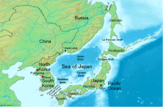
The Sea of Japan is called Nihon kai in Japan and Rìběn hǎi in China.
Sea of Japan
Multiple
The Sea of Japan (see § Names for other names) is the marginal sea between the Japanese archipelago, Sakhalin, the Korean Peninsula, and the mainland of the Russian Far East. The Japanese archipelago separates the sea from the Pacific Ocean.
From the “Names” section
Text from Wikipedia, CC BY-SA 4.0.
Photo: Sea of Japan Map.png: Chris 73 derivative work: Phoenix7777 (talk) · CC BY-SA 3.0

The old Baiyun Airport opened in 1932 and was closed when the new airport opened on 5 August 2004.
Guangzhou Baiyun International Airport
China
Guangzhou Baiyun International Airport is the international airport serving Guangzhou, Guangdong, China.
From the “Overview” section
Text from Wikipedia, CC BY-SA 4.0.
Photo: Jacky Cheung · CC BY-SA 4.0

The Indigenous peoples, the Ciboney, called the island Xaymaca, meaning the 'Land of Wood and Water'.
Jamaica
Jamaica is an island country in the Caribbean, covering 10,990 square kilometres (4,240 sq mi). It is the third-largest island in the Greater Antilles and the Caribbean, after Cuba and the island of Hispaniola.
From the “Etymology” section
Text from Wikipedia, CC BY-SA 4.0.
Photo: CaptJayRuffins · CC BY-SA 4.0

Kuala Lumpur means 'muddy confluence' in Malay.
Kuala Lumpur
Malaysia
Kuala Lumpur (KL), officially the Federal Territory of Kuala Lumpur, is the capital city and a federal territory of Malaysia. It is the most populous city in the country, covering an area of 243 km2 (94 sq mi) with a population of 2,075,600 as of 2024.
From the “Etymology” section
Text from Wikipedia, CC BY-SA 4.0.
Photo: Shahee Ilyas · CC BY-SA 4.0

The name Puncak Jaya is Indonesian for 'Glorious Peak'.
Puncak Jaya
Indonesia
Puncak Jaya or Carstensz Pyramid on the island of New Guinea, with an elevation of 4,884 m (16,024 ft), is the highest mountain peak of an island on Earth, and the highest peak in Indonesia and within Oceania. The mountain is located in the Sudirman Range of the highlands of Mimika Regency, Central Papua, Indonesia.
From the “Etymology” section
Text from Wikipedia, CC BY-SA 4.0.
Photo: Enda Kaban · CC BY-SA 4.0

The Senegal River has a drainage basin of 270,000 km².
Senegal River
Multiple
The Senegal River ; Wolof: Dexug Senegaal, Arabic: نهر السنغال, romanized: Nahr as-Siniġāl, Hassaniyya pronunciation: [nahrˤ əs.säjnigaːl], French: Fleuve Sénégal) is a 1086-kilometre-long (675 mi) river in West Africa; much of its length marks part of the border between Senegal and Mauritania.
From the “Geography” section
Text from Wikipedia, CC BY-SA 4.0.
Photo: WILLAV-FR · CC BY-SA 4.0

Lake Huron is the second-largest of the Great Lakes by surface area, covering 23,000 square miles.
Lake Huron
Multiple
Lake Huron is one of the five Great Lakes of North America. It is shared on the north and east by the Canadian province of Ontario and on the south and west by the U.S. state of Michigan.
From the “Geography” section
Text from Wikipedia, CC BY-SA 4.0.
Photo: NASA · Public Domain

The name Sulawesi possibly comes from the words sula ('island') and besi ('iron').
Sulawesi
Indonesia
Sulawesi, also known as Celebes, is an island in Indonesia. One of the four Greater Sunda Islands, and the world's 11th-largest island, it is situated east of Borneo, west of the Maluku Islands, and south of Mindanao and the Sulu Archipelago.
From the “Etymology” section
Text from Wikipedia, CC BY-SA 4.0.
Photo: Sadalmelik · CC BY-SA 3.0
You have seen 1440 facts
Keep exploring - or dive deeper into a place page.